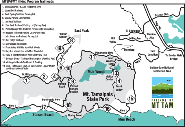
Trailheads
Friends of Mt Tam guided hikes regularly utilize 17 trailheads in or adjacent to the State Park.
Trailhead directions are below.
Also available on google maps.
Though be aware that some numbers have been removed since the park facilities have been updated in recent years.

| Name | Description | |
|---|---|---|
| #1 | Bolinas-Fairfax | Limited parking at the intersection of West Ridgecrest and Bolinas-Fairfax Road 3.8 miles from Rock Spring. Parking for several cars. |
| #2 | Laurel Dell | The Laurel Dell Trailhead is located on West Ridgecrest Blvd., on the right, about 1.5 miles past Rock Spring, take the left fork at Rock Spring, Pantoll Rd. ends here. There is a roadside parking lot for about fifteen cars at the Laurel Dell Trailhead. A distinguishing feature at this location is a rust colored iron gate in the middle of the parking area, across the entrance to a fire road here. |
| #4 | Rock Spring | Large Parking Area located at the end of Pantoll Road (Across from the Pantoll Parking Area). Rock Spring is 1 mile further up Pantoll Road. Restroom is available. |
| #6 | Quarry Parking Lot | Parking area (dirt and gravel) located on East Ridgecrest Blvd 0.4 miles from Rock Spring. |
| #7 | West Peak Air-Base | Parking near locked gate of old Air Base 1.1 miles from Rock Spring. Do not block access to gates. Parking for several cars. |
| #8 | East Peak | (Fee Parking) East Peak Parking, Restrooms/Water, Visitor Center, Gravity Car Museum, Fire Tower. End of E. Ridgecrest Blvd. |
| #9 | Pantoll | (Fee Parking) Campground, Restrooms/Water, Kiosk, Ranger Station. On Panoramic Hwy within Mt Tam State Park. |
| #10 | Bootjack | (Fee Parking) Campground, Restrooms/Water. On Panoramic Hwy within Mt Tam State Park. |
| #11 | Mt Home | State Park Parking Area on Panoramic Hwy across the street from the Mt Home Inn. Restrooms. |
| #12 | Dias Ridge | This meeting location lies along Panoramic Highway, about halfway between the turnoff of Highway 1, (the turnoff for Mt. Tam State Park), and the four corners intersection (this is the turnoff for Muir Woods). Hikers can park on the east side of Panoramic Highway, about ¾ of a mile from the Highway 1 turnoff. Sometimes there is a vendor here selling fruit and nuts from a pick-up truck. |
| #13 | Muir Woods | RESERVATIONS REQUIRED Drive to Muir Woods, bypass the parking lot at the last hairpin turn on the way down at the bottom. The next parking lot (Annex Lot) on the right, parallel/next to, to Muir Woods Rd., is the meeting location. (note: The walk-in entrance to Muir Woods is not the meeting location.) Restrooms/Water are available at the Muir Woods Visitor Center. |
| #14 | Frank Valley | MUIR WOODS RENOVATIONS IN PROGRESS, PARKING MAY BE UNAVAILABLE. This meeting location is along Muir Woods Rd. Proceed about ¾ of a mile past the Muir Woods Annex Lot (see above directions). Parking is along the left side of Muir Woods Rd., opposite the Deer Park Fire road gate on the right and very close to the trail sign for Miwok Trail on the left. Note: Parking is typically not available after 9am on weekends. |
| #15 | Hwy One and Muir Woods Rd | MUIR WOODS RENOVATIONS IN PROGRESS, PARKING MAY BE UNAVAILABLE. After exiting the 101 freeway at the Hwy 1/Stinson Beach Exit, continue on Hwy 1 west for about seven miles. Pass the Pelican Inn. In about a quarter mile make a right onto Muir Woods Rd. and immediately look to your left. There is a very wide shoulder legal for parking. Be sure to pull completely off the road when you park. |
| #16 | Hwy One and Coast View Trail | Roadside Parking south of Slide Ranch on Shoreline Highway (West side of the highway) approximately 1.6 miles north of Pelican Inn and 0.3 miles north of the Muir Beach Overlook. |
| #17 | Stinson Beach Park | Stinson State Beach Park, CA Hwy 1 in Stinson Beach. Drive straight into State Park, then curve left. Park near picnic tables on right. Restrooms are available. |
| #18 | Whitegate Ranch | This trailhead is along Panoramic Highway about 2.5 miles past Pantoll Ranger Station. After driving past Pantoll Ranger Station starts a long steep descent to Stinson Beach. Panoramic Highway is wooded for about 2.25 miles after passing the Ranger Station. The trailhead is in the open, on the left (Parking alongside of road for about 12 cars.) just after the second hairpin turn after coming out of the wooded part of Panoramic Highway. When you see the water tank on the left you are almost there. |
| #19 | Upper Miller | E. Ridgecrest Blvd. –Miller Trailhead is On E. Ridgecrest Blvd.at intersect of Upper Miller Trial and International Trial before East Peak. Parking for several cars. |
